A GPS/CDPD Vehicle Tracking System
|
|
TRACER A GPS/CDPD Vehicle Tracking System | |||
TRACER: An Extensible Data Collection System
Integrating GPS, GIS, and Wireless Technologies for Traffic Surveillance and Management
M. G. McNally <mmcnally@uci.edu>
James Marca <jmarca@translab.its.uci.edu>
Craig R. Rindt <crindt@translab.its.uci.edu>
Institute of Transportation Studies and
Department of Civil & Environmental Engineering
University of California Irvine
Irvine, CA 92697-3600 USA
Funded by the Caltrans ATMS Testbed and California PATH.
TRACER System Overview
Despite recent advances in Intelligent Transportation System (ITS) technologies,
the potential for improving transportation system performance is restricted by a
limited understanding of the relationships between transportation system performance
and characteristics of travel demand. While models of supply tell us what we should
do under various traffic scenarios, there is little that we may confidently implement
due to a fundamental lack of understanding of individual travel demands and route
utilization. The difficulty in obtaining reliable and accurate travel behavior data
is one of the primary reasons individual travel behavior and route selection is so
poorly understood. Global Positioning Systems (GPS) are one of several available
technologies that allow individual vehicle trajectories to be recorded and analyzed.
The TRACER System is a portable, automated in-vehicle data collection system that integrates GPS with wireless communications that allows data to be accessed and the vehicle to be tracked at any time the vehicle is under power (while eliminating driver interaction). A set of generic applications can be defined that span functional requirements, including: (a) Basic (basic multi-day survey of vehicle trajectories), (b) Probe (obtaining real-time traffic stream conditions via probe vehicle), (c) Enhanced (enhanced multi-day trajectory survey with behavioral logging), and (d) Route Guidance (routing behavior under real-time route guidance).
[ back to top ]
TRACER System Specifications
The TRACER system incorporates an Extensible Data Collection Unit (EDCU) with a suite
of base station processing software for both real-time and post-processing. These
self-contained units are based on a power-efficient x586-class, 133 MHz microprocessor
running a Linux-based embedded operating system. The unit has 32 Mb of RAM, uses 16 Mb
flash-RAM as its primary storage, and controls both a GPS receiver and a cellular
digital packet data (CDPD) modem. The operating system runs programs to control the
defined EDCU functional applications. The units were designed by
ITS project team and
AeroData.
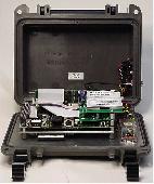
Figure 1 shows the interior of the unit with input/output ports, flash ram,
and the CDPD modem. A second generation unit in design places an 802.11b
card parallel to the CDPD card enabling local wireless communications with
a laptop or PDA for system configuration or user interface. Figures 2 and 3
show exterior EDCU views, including power, GPS, and CDPD connections (the
3.5 inch disk provides scale).
Under normal operation, the units are designed to operate by tapping a
vehicle's power supply via an auxiliary power port (e.g. cigarette lighter).
With the addition of a battery pack, they can also be isolated from the
vehicle's power for short duration applications. The units are enclosed
in a sturdy, weather resistant case that is suitable for a wide range of
vehicle implementation options. Because the equipment was intended to fill
multiple data collection roles with significantly different requirements,
versatility was a primary design goal. The data collection system employs
a modular design to ensure such flexibility, comprising:
TracerMap
The GPS-based survey data is integrated with a geographic information
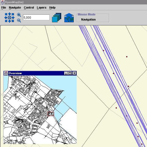
system (GIS) for real-time and post-processing. BBN Technologies' OpenMap
(http://openmap.bbn.com) GIS is written in Java and is ideally suited to
be Internet-based. The software probes an EDCU over the Internet and
posts that and other spatial data (such as other sensor inputs) to a map
for display and analysis.
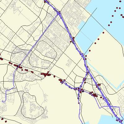 |
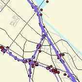
TracerMap: Regional and Corridor Views (Click on each image for a full size version) |
 |
The ANNE Web-based Survey
The ANNE web site provides a real-time
display of EDCU tracings and also provides an annotation capability facilitating
realtime travel/activity surveys [ANNE is still underdevelopment and access is limited
to Beta test respondents].
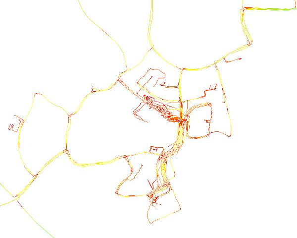 |
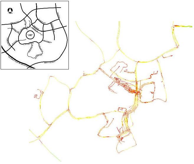
ANNE Composite View: UCI Trip Origins (1 vehicle for 2 weeks) [ Link Color indicates speed from slow (red) to fast (green) ] (Click on the image for a full size version) (UCI Map) |
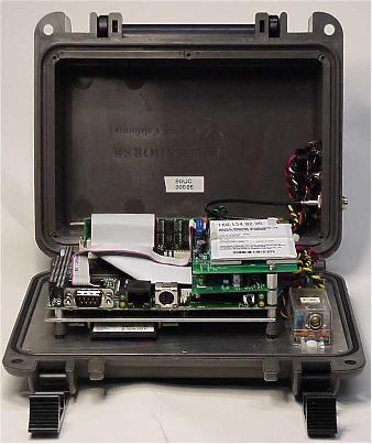 Figure 1. EDCU Interior View |
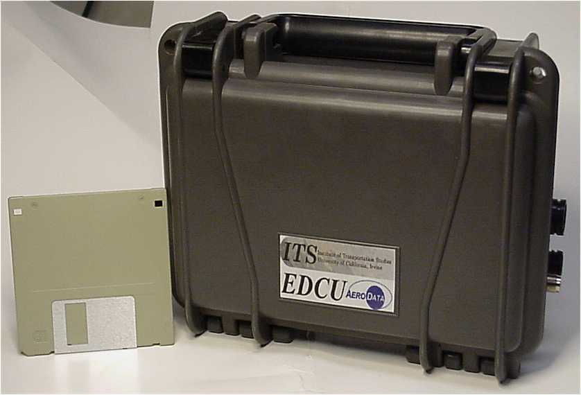 Figure 2. EDCU Exterior View |
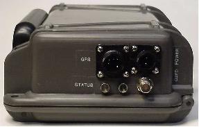 Figure 3. EDCU Connection Panel | |
[ back to top ]
Current Applications of the Tracer System
[ back to top ]
Tracer Papers and Reports
| AS-WP-02-10 | GPS/GIS Technologies for Traffic Surveillance and Management. Final Report to California PATH, TO 4120 Michael G. McNally, James E. Marca, and Craig R. Rindt. April 2003. |
| AS-WP-02-4 | Towards Distributed Data Collection and Peer-to-Peer Data Sharing. James E. Marca, Craig R. Rindt. and Michael G. McNally. August 2002. 15 pp. |
| AS-WP-02-3 | Collecting Activity Data from GPS Readings. James E. Marca, Craig R. Rindt, and Michael G. McNally. August 2002. 15 pp. |
| AS-WP-02-2 | The Tracer Data Collection System: Implementation and Operational Experience. James E. Marca, Craig R. Rindt, and Michael G. McNally. July 2002. 11 pp. |
| AS-WP-02-1 | The Design and Implementation of an On-Line Travel and Activity Survey. James E. Marca. August 2002. 8 pp. |
| Dissertation | Activity-based Modeling in the Wireless Information Age, unpublished
PhD dissertation, Department of Civil and Environmental Engineering,
University of California, Irvine. James E. Marca. December 2002. |
| AS-WP-02-1 | GPS/GIS Technologies for Traffic Surveillance and Management: A Testbed Implementation Study,
California PATH Report to Caltrans, MOU 3006, UCB-ITS-PWP-2002-7, Richmond, CA. Michael G. McNally, James E. Marca, Craig R. Rindt, and Angela M. Koos. December 2002. 68 pp. |
| AS-WP-00-14 | A GPS-based In-Vehicle Data Collection System: A Comparison with Conventional Loop Data,
North American Travel Monitoring Conference and Exhibition (NATMEC), Madison WI Michael G. McNally, James E. Marca, Craig R. Rindt, and Angela M. Koos. June 2002. |
| AS-WP-00-9 | A GPS Enhanced In-Vehicle Extensible Data Collection Unit. James E. Marca, Craig R. Rindt, Michael G. McNally, and Sean Doherty. December 2000. 21 pp. |
| AS-WP-99-5 | GPS Enhanced In-vehicle Data Collection Technologies for Traffic Surveillance
and Travel Surveys: Technical Requirements and Potential Solutions. Craig R. Rindt, James E. Marca, Sean Doherty, and Michael G. McNally. June 1999. |
[ back to top ]
